Laser Scanning
PBH harness the benefits of laser scanning to ensure a more robust delivery Download BrochureLaser Scanning Surveys
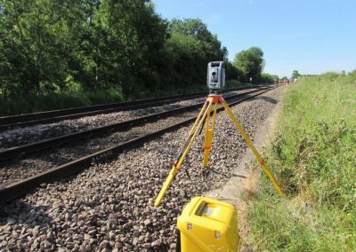
When surveying some of the largest and most complex structures on the network, PBH harness the benefits of laser scanning to ensure a more robust deliverable.
Some of the benefits of laser scanning include:
- Entire & accurate dimensions
- A repeatable 3D environment allowing for easy navigation.
- Geo-referenced information which can be linked to design projects.
- Provision of an accurate basis to build infrastructure models.
- Safe non-contact data capture even in difficult or dangerous places to access.
- A ‘Capture-All/Capture-Once’ methodology to reduce the need for site revisits.
- An insurance policy against future scope creep – the data is there even if not required at the project outset.
PBH Surveys can deliver outputs directly tailored to client requirements:
- ‘Traditional’ Linework/linestyles 2D Drawings – dgn/.dwg
- ‘Traditional’ 3D Wireframe Drawings –.dgn/.dwg
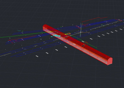
- ‘Simple Hybrid’ 3D Wireframes/Solid Models – combining traditional track surveys with 3D Solid models of complicated structures – dgn/.dwg/.rvt/.msh
- ‘Complex Hybrid’ 3D Wireframes/Solid Models – Full solid models of all infrastructure supplemented with traditional topographic surveys – dgn/.dwg/.rvt/.msh
- Total 3D Solid Models – No traditional Linework. – dgn/.dwg/.rvt/.msh
All deliverables can be tailored to suit time/cost budgets
- Outline Detail – Building Shapes/groundforms – representative components.
- Medium Detail – Building Shapes/Features – basic componentry accurately depicted.
- High Detail – WYSIWYM “What You See Is What You Model” Accurate depictions of all features required in specification.
- Rendered High Detail – Photorealistic Models used for heritage grade/planning applications etc
Recent Projects
Here are a couple of key projects we are perticularly proud of.
Client Testimonials
Here are a couple of testimonials our clients have written.